

There are Carolina Bays in Virginia, but many of them are on hard ground. Glacier ice boulders impacting this hard surface were not able to create the flat elliptical features found in the bays in North or South Carolina.
The Carolina Bays are shallow elliptical basins with raised rims that are found along the Atlantic Coastal Plain from New York to Florida. The most well preserved Carolina Bays are in the loose sandy soil of North and South Carolina. This presentation will discuss the Carolina Bays that are found on the hard and rocky ground of Virginia.
Virginia has several prominent geological areas. The eastern part of Virginia is the coastal plain along Chesapeake Bay. The fall line marks the transition between the Coastal Plain and the Piedmont. There are many waterfalls and rapids in the streams that cross this line. To the west of the fall line, the piedmont increases in elevation toward the Blue Ridge Mountains in the Appalachian Highlands. The coastal plain has many flat areas indicated by a single color in the colorized topography of this LiDAR image. Today we will be looking at Carolina Bays close to the fall line around the cities of Richmond, Chester and Petersburg.
The Glacier Ice Impact Hypothesis proposes that an extraterrestrial impact on the Laurentide Ice Sheet ejected pieces of glacier ice in ballistic trajectories and the oblique secondary impacts of the ice boulders created the Carolina Bays.
There are several large Carolina Bays to the east of Richmond, Virginia. The ice projectiles impacting the hard terrain were not able to create the typical basins found in North or South Carolina, but they still created elliptical features. The Carolina Bays in Virginia can be shown to be elliptical by selecting points along the well-defined rim of a basin, and fitting the points with an ellipse by the least squares method. Only five points are needed to fit an ellipse, so the ellipse-fitting procedure makes it possible to determine the dimensions of the complete basin. This is a very large Carolina Bay with a major axis of 7,058 meters and a minor axis of 4,699 meters. The ellipse has a fitting error of 1.7 percent, which is a very good fit.
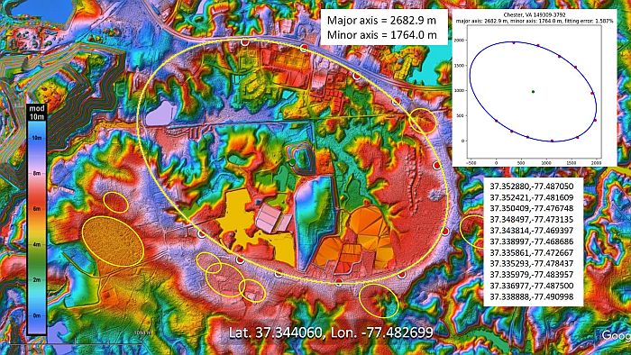
This LiDAR image shows a large Carolina Bay 3.6 kilometers southwest of Chester, Virginia. Rain on the uneven terrain has severely eroded the bays in this area. Although this terrain is highly eroded, some of the rims are still well defined, and it is possible to fit the points with an ellipse. This Carolina Bay has a major axis of 2682 meters, which is about 1.7 miles. There are several smaller bays to the southwest of the large bay, and one of them has a well-defined rim. Some of the bays in this LiDAR image overlap, and many have almost disappeared due to erosion and urban development. We can place some ellipses on the ghostly remains of the bays to get an idea of what the terrain looked like thousands of years ago.
The well-defined portion of this bay enables us to reconstruct its elliptical geometry with a major axis of 562 meters. The selected points fall within the path of the ellipse with a fitting error of 0.559, which is a very precise fit. There are some Carolina Bays about 10 kilometers west of Petersburg, Virginia, on the relatively flat portions of the hilly terrain by the fall line. The Carolina Bays do not look particularly regular due to the extremely eroded surface. The landscape makes more sense when it is interpreted as a cluster of basins that have merged by water erosion. Points can be selected along the rim of the large basin where erosion has not caused deformations. The major axis of this Carolina Bay is 937 meters and the fitting error of the ellipse is 1.144 percent.
The Glacier Ice Impact Hypothesis proposes that secondary impacts of glacier ice created inclined conical cavities that transformed into shallow elliptical bays by viscous relaxation. The rocky ground in Virginia would not have allowed the formation of penetration funnels like those that were made in the saturated, unconsolidated soil of North Carolina or South Carolina where the ground was liquefied by the seismic vibrations of the impacts. Instead, the Carolina Bays in Virginia were made by ice boulders that disintegrated on impact and plowed gravel and stony debris out of the way to leave the elliptical features that we see today. The mechanism is similar to the elliptical spatter patterns studied in forensic science.
This is an experimental impact of an ice projectile fired from a slingshot toward the concrete floor. The projectile disintegrates into many fast moving ice shards. Since the projectile does not penetrate the surface, there are no barriers to stop the horizontal expansion of the ice pieces that originate from the point of impact. We can see that shortly after the impact, the ice fragments form an elliptical pattern, but at this point the ice pieces still have a lot of kinetic energy and have not come to rest.
In 2017, a massive block of ice fell from a passing airplane and left a five-foot crater in the garden of a family in the village of Busby, Scotland. Notice the ice pieces and the raised rims around the cavity, which are typical of impact cratering. The Carolina Bays in the hard ground in Virginia may have formed by a similar mechanism.
This image compares the Carolina Bays on uneven rocky terrain in Virginia with the bays on sandy terrain in North Carolina. The bays in North Carolina are flat enough to be farmed. Notice that the large bay in North Carolina has eolian sand sheets, which are evidence of the strong winds that accompanied the formation of the Carolina Bays. In spite of the substantial geological differences of the terrains in Virginia and North Carolina, it is significant that all these bays have a mathematically elliptical geometry. The hypothesis that wind and water mechanisms created the Carolina Bays cannot explain how these precise elliptical features were made on the hilly and rocky terrain of Virginia.
